 Catalogue PIGMA
Cogea srl
Type of resources
Topics
Keywords
Contact for the resource
Provided by
Years
Formats
Representation types
Update frequencies
status
Scale
Resolution
-
This dataset stems from the Joint Research Centre (JRC) Biomass Mandate (https://knowledge4policy.ec.europa.eu/projects-activities/jrc-biomass-mandate_en) and it is available for viewing and download on EMODnet - Human Activities web portal (www.emodnet-humanactivities.eu) and on the platform from the European Commission’s Knowledge Centre for Bioeconomy (https://knowledge4policy.ec.europa.eu/visualisation/bioeconomy-different-countries_en#algae_prod_plants). Its aim is to build a reliable database to characterize the algae sector and to support informed European policies on Blue Growth and Bioeconomy. More detailed information on the Status of the Algae Production Industry in Europe can be found in a JRC-led study published in Frontiers in Marine Science (https://publications.jrc.ec.europa.eu/repository/handle/JRC122250). Information on the location (geographic coordinates) of the production facilities, group of produced organism (macroalgae, microalgae and spirulina), production method (Fermenters, Harvesting , Photobioreactors, Open ponds, Semi Open ponds, land-based or at sea Aquaculture, Integrated multi-trophic or not) and species (see dataset) have been collected in the following countries: Austria, Belgium, Bulgaria, Croatia, Czech Republic, Denmark, Estonia, Faroe Islands, France, Germany, Greece, Greenland, Hungary, Iceland, Ireland, Italy, Latvia, the Netherlands, Norway, Portugal, Spain, Sweden, Switzerland and the UK. In November 2021, the JRC has updated the database with the latest information on the production units operational at the time.
-
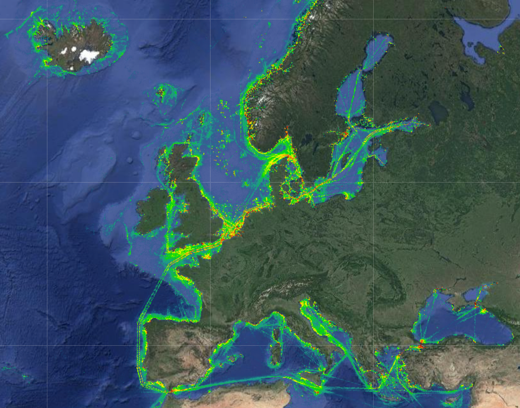
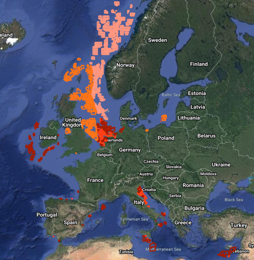
The Vessel Density maps in the EU were created in 2019 by Cogea for the European Marine Observation and Data Network (EMODnet). The dataset is updated every year and is available for viewing and download on EMODnet Human Activities web portal (www.emodnet-humanactivities.eu). The maps are based on AIS data yearly purchased from Collecte Localisation Satellites (CLS) and ORBCOMM. The maps, GeoTIFF format, show shipping density in 1x1km cells of a grid covering all EU waters and some neighbouring areas. Density is expressed as hours per square kilometre per month. The following ship types are available:0 Other, 1 Fishing, 2 Service, 3 Dredging or underwater ops, 4 Sailing, 5 Pleasure Craft, 6 High speed craft, 7 Tug and towing, 8 Passenger, 9 Cargo, 10 Tanker, 11 Military and Law Enforcement, 12 Unknown and All ship types. Data are available by month of year. Yearly averages are also available.
-

The dataset on Natura 2000 sites was created in 2014 by Cogea for the European Marine Observation and Data Network. It is entirely based on spatial data from the European Environmental Agency (EEA), plus additional info, links and selected EEA data joined to the feature attributes, as well as a calculation by Cogea of marine and coastal location of features. It is available for viewing and download on EMODnet - Human Activities web portal (www.emodnet-humanactivities.eu). Natura 2000 is an ecological network composed of sites designated under the Birds Directive (Special Protection Areas, SPAs) and the Habitats Directive (Sites of Community Importance, SCIs, and Special Areas of Conservation, SACs). The dataset covers the whole EU. Following the United Kingdom’s withdrawal from the EU on 31 January 2020, it ceased to be part of the EEA’s institutional networks and governance. In the webmap the EEA dataset has been filtered by Cogea to show only (i) marine sites, i.e. sites with a marine area percentage higher than 0 (as calculated by the EEA) and (ii) sites that, even if not identified as marine by the EEA, intersect the EEA coastline or that are within a distance of 1 km from the coastline (using a 1 km inner buffer from the EEA coastline). In both cases the COAST_MAR field value=1. The EEA coastline dataset is available at https://www.eea.europa.eu/data-and-maps/data/eea-coastline-for-analysis-2. Compared with the previous version, this one includes the updated dataset 'Natura 2000 End 2020', published by the EEA in July 2021. For further information (e.g. biogeographic region, directive, habitats, sites, impact, management, species and metadata) please visit the EEA's website hosting the Natura 2000 tabular data.
-
-
-
-
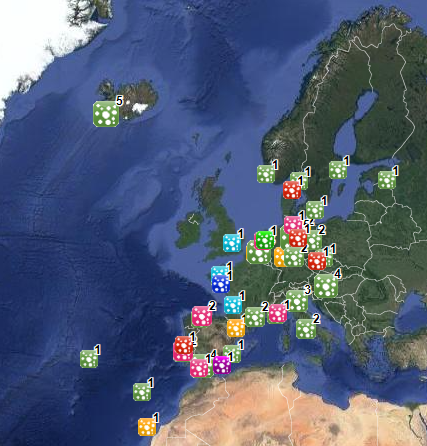
The dataset on offshore installations for Oil and Gas exploitation and exploration activities was created in 2015 by Cogea for the European Marine Observation and Data Network (EMODnet). It is the result of the aggregation and harmonization of datasets provided by several EU and non-EU sources. It is updated every year, and is available for viewing and download on EMODnet - Human Activities web portal (www.emodnet-humanactivities.eu). The dataset contains points representing offshore installations and where available each point has the following attributes: ID, name, country, location block, operator, production start year, primary production, current status, category and function of the installation, sub-structure and topside weights (tonnes), water depth (metres), distance to coast (metres) and remarks. The OSPAR commission source covers data for Germany, Ireland, Spain and the United Kingdom, while for Italy data have been collected and harmonized from the Italian Ministry of Economic Development, for Norway from the Norwegian Petroleum Directorate, for Denmark from the Danish Energy Agency, for the Netherlands from the TNO - Geological Survey of the Netherlands, for Croatia from the Croatian Hydrocarbon Agency, from Marine Traffic and Helcom data on Polish and Russian installations in the Baltic Sea, from Marine Traffic data on Bulgarian, Russian and Ukrainian installations in the Black Sea, Lybian and Spanish installations in the Mediterranean Sea. Compared with the previous version this new version has been updated for all countries.
-
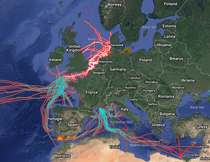
The datasets on subsea telecommunication and power cables (actual routes) in the EU was created in 2014 by Cogea for the European Marine Observation and Data Network (EMODnet). It is the result of the aggregation and harmonization of datasets provided by several sources. It is updated every year and is available for viewing and download on EMODnet Human Activities web portal (www.emodnet-humanactivities.eu). The datasets contain lines representing actual cable routes locations. Compared with the previous version, this version includes an update of the French telecommunication cables, the telecommunication cables that originate from or pass through Spanish (Andalucia) and Dutch waters, and the electric cables that originate from or pass through French, Dutch and Norwegian waters.
-
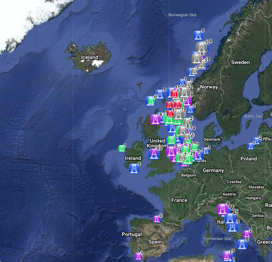
The dataset on offshore active licences for Oil and Gas exploitation and exploration in the EU was created in 2014 by Cogea for the European Marine Observation and Data Network (EMODnet). It is the result of the aggregation and harmonization of datasets provided by several EU and non-EU sources. It is updated every year, and is available for viewing and download on EMODnet - Human Activities web portal (www.emodnet-humanactivities.eu). It contains polygons representing active offshore licenced areas in the following countries: Croatia, Cyprus, Denmark, France, Germany, Ireland, Italy, Malta, Netherlands, Norway, Poland, Spain and United Kingdom. Where available each polygon has the following attributes: country, code, name, type (exploitation, exploration, exploitation and exploration, other, N/A), licensing round (it includes also pending applications in France and Spain), area (square km), area info (it indicates if the area value is original from the source or has been calculated), starting year, ending year, operator or administrator. Compared with the previous release, 'Exploitation, exploration' new type of licence has been added. Italy's exploration licences are all temporarily suspended.